| |
| Map Products |
| GPS Products |
| Projects |
| Community |
| Contact |
| GPS Products |
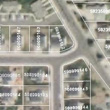
Does your GIS float? GIS data and maps have traditionally been part of the desktop and office scene. But, what if the GIS were mobile and what if it floated? That is what Cartomations GPS system can do, a GPS with parcel data inside and it floats. Imagine instead of seeing the same old road network in your GPS, you are driving down the plat with parcels going by. You turn, it turns with you. You can see the information scrolling along as you drive through it. SMITH, John is mowing his lawn ahead. Why not stop and say hello and walk him around to all of his property corners? After all, our GPS has all of the attributes and you always know where you are.
|
| NEW MAPS | ||
|
||